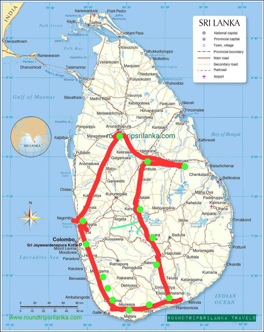
Maps
Sri Lanka, is an independent island state, consisting of a main island and some small islands. The island nation is located 30 km (19 mi) southeast of the southern coast of India in the Indian Ocean, between the Laccadive Sea in the west and the Bay of Bengal in the east.
In 1948, British Ceylon was granted independence. In 1972 the island became a republic within the Commonwealth, and its name was changed to Sri Lanka. The country shares maritime borders with the Maldives and India.
Sri Lanka’s landscape area of 65,610 km mostly low with flat to rolling coastal plains. In the south-central interior of the island is a mountainous region. There is the country’s highest mountain Pidurutalagala, (Mount Pedro) at 2,524 m.
The island has a tropical climate moderated by ocean winds.
Sri Lanka has a population of 21.92 million people (in 2020). The official capital is Sri Jayewardenepura Kotte; the largest city and administrative capital is Colombo Spoken languages are Sinhala (official and national language) 74%, Tamil (national language) 18%, other 8%. About 10% of the population speak English as a second language.
The map shows the island of Sri Lanka with provincial capitals, major cities and towns, main roads, railroads, and major Airports
NORTHERN PROVINCE
Jaffna (capital of the Northern Province), Kayts, Kilinochchi, Mannar, Mullaittivu, Point Pedro, Talaimannar, Vavuniya,
NORTH CENTRAL
Anuradhapura (one of the ancient capitals, and todays capital of North Central Province), Habarana, Sigiriya, Horuwupotana, Kebitigollewa, Kekirawa, Maragahewa, Medawachchiya, Polonnaruwa.
NORTH WESTERN
Kurunegala, Chilaw, Maho, Anamaduwa, Galgamuwa, Puttalam, Kalpitiya.
EASTERN PROVINCE
Amparai, Batticaloa, Chenkaladi, Kalmunai, Kantalai, Kumana, Maha Oya, Mutur, Nilaveli, Okanda, Pottuvil, Pulmoddai, Tirrukkovil, Trincomalee, Uhana, Valachchenai.
CENTRAL PROVINCE
Kandy (second largest city in the country), Dambulla. Matale, Nuwara Eliya, Hatton. Adamspeak, Nanu-Oya,
WESTERN PROVINCE
Colombo (major seaport, largest city and cultural center of Sri Lanka), Sri Jayewardenepura Kotte (New Capital Territory, seat of the Parliament of Sri Lanka and de jure capital)
Gampaha, Negombo, Ja-Ela, Mount Lavinia, Moratuwa, Kalutara, Beruwela Panadura,
UWA PROVINCE
Badulla, Ella, Bandarawela,
SABARAGAMUWA PROVINCE
Balangoda, Embilipitiya, Kegalle, Ratnapura (the “City of Gems”, famous for the trade of precious stones, capital city of Sabaragamuwa Province)
SOUTHERN PROVINCE
Galle, Hikkaduwa, Unawatuna, Mirissa, Bentota, Ambalangoda, Hambontota, Matara, Tangalla, Weligama, Tissamaharama,
General Weather Forecast
Average mean temperature along the coast is 26.7º C (80 F) and 19.7º C (66.50 F) in the hill country.
In Colombo, the commercial capital, situated on the west coast, the temperature varies from 26.4º C (79.5 F) to 27.8º C (82.12 F). Relative Humidity varies from 70% during the day to 90% at night. In the lowlands the climate is typically tropical with an average temperature of 27º C in Colombo.
In the higher elevations it can be quite cool with temperatures going down to 16Oº C at an altitude of nearly 2,000 meters. Bright, sunny warm days are the rule and are common even during the height of the monsoon – climatically Sri Lanka has no off season.
The south west monsoon brings rain mainly from May to July to the western, southern and central regions of the island,
while the north-east monsoon rains occur in the northern and eastern regions in December and January.
Annual 2540 mm to over 5080 mm in south west of the Island. Less than 1250 mm in the north west and south east of the Inland.
Sunny seasons
South and West – Nov to April
North and East – May to October
Rainy Seasons
South West Monsoon – May to August
North East Monsoon – November to February

